Digital Divide
While most industries have undergone tremendous changes over the last few decades and have reaped the benefits of process and product innovations, the Engineering & Construction (E&C) sector has been hesitant about embracing the latest technological opportunities, and its labour productivity has stagnated accordingly. The E&C sector has not undergone any major disruptive changes; it has not widely applied advances in processes such as “lean” techniques. As a result, efficiency gains have been meagre.
This slow pace of innovation matters because of the great scope and scale of the E&C sector. It’s a growing industry and a large consumer of resources, using billions of tons of raw material and producing a large percentage of the world’s carbon emissions. Only through improvements in economic performance and social outcomes and reduction in environmental impact can this situation be changed.

As the owner of an extensive portfolio of infrastructure and real property assets, DND has a role to play in changing these practices. In response to this need and its business modernization program, DND has created the Real Property Spatial Data Warehouse. Its purpose is to centralize real property assets in a digital data environment that supports DND and its business partners in achieving cost and efficiency gains through better business practices.
Digital transformation involves the integration of digital technology into all areas of DND business operations, driven by a sustainable and enterprise data environment. Building information modelling (BIM) is an integral part of this transition as it helps designers, contractors, operators, and owners adapt more easily to changing asset usage. Digitizing our built environment can economize building and infrastructure construction so assets are more cost effective, better designed, and sustainable now and into the future.
Why DND is changing
DND is the custodian of a massive real property portfolio, which includes land, buildings, and civil infrastructure. We are living in a unique time as rapidly maturing technologies offer real value to the way we manage our built assets, and these technologies are serving up unprecedented volumes of data. Along with the rest of the real property world, DND has been watching these advancements transform asset life cycle management. Innovative and digitized processes have meanwhile benefited other industries for decades. Like many organizations that experience a sea change, we have been called to action: Resolve a fundamental problem of inefficiency.
The problem with putting pencil to paper.
Ideas on paper signal a traditional design process, but the downside of paper-based workflows is that data doesn't always make it off the page. Even when architectural drawings transitioned to the screen through computer-aided design, there were missed opportunities to leverage data. This silo mentality of managing infrastructure and environment information in isolation is what has led to departmental inefficiencies and is the reason we need to move to a data-driven business model.
Like other owners of built assets, DND has relied on outdated practices where fragmented information management has translated to repetitive efforts, project information being lost at handover, and corporate systems that aren't integrated. At the root of this layered problem was a lack of trust in data.
A call to modernize.
As an agile steward of assets, DND responds to government-wide drivers while taking cues from industry and requirements from consultants. In 2016 real property management was centralized under one custodian, and the following year a new policy, Strong, Secure, Engaged, set the directive to modernize our business, with an emphasis on data management.
We have been preparing for a transition to data-driven digital workflows for years. Perhaps more than anything, the change requires a shift in how we think about data accessibility. Data should not be tethered to a single user or application or stuck in a silo that systems can't access. The true value of asset data is in its capacity to be centralized, verified, and shared.
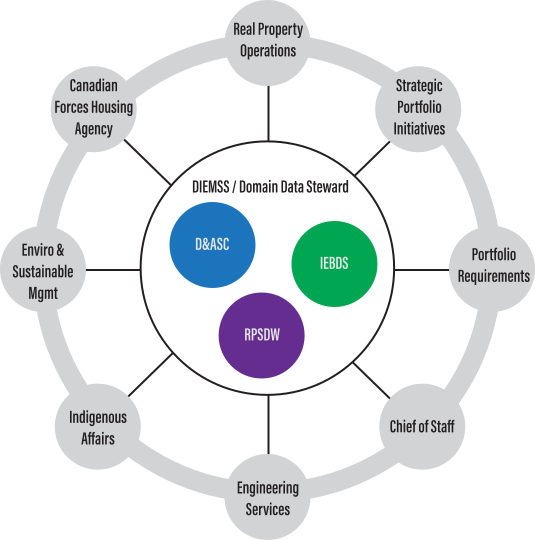
ADM(IE) is exploring a phased transition to a hub-and-spoke management model that will enable data sharing and alignment of activities between functional and technical authorities. A data and analytics support centre will be positioned to provide governance, standards and coordinated data reporting to ensure that trusted data empowers all IE functions.
Spatial data for all.
Our early steps to improve data management trace back to the sharing of common technical standards and tools across CAD and GIS communities as a measure to streamline efforts. We later refined our focus to standardize real property spatial information according to areas of interest: buildings, site, infrastructure and land. It was through national workshops and communication across technical committees that we garnered consensus to shift toward maintaining “spatial data for all.” In the meantime, BIM was gaining momentum in industry as a game-changer for the built asset life cycle, and DND released a hybrid CAD/BIM Data Standard in 2012. All of this groundwork led to the development of a spatial data warehouse where information across the real property portfolio can be exchanged to inform various systems and processes.
The future is digital.
As many of our daily transactions have adapted to a digital landscape—from consuming news to banking—automated processes are changing how we interact with asset information. It’s because of industry advancements and the call to modernize that we’ve adopted technologies and processes such as building information modelling. BIM allows us to collaborate with key stakeholders across disciplines and maintain a “digital twin” where data can be checked and updated as changes to the physical asset happen.
We’re engaging with other departments such as Public Services and Procurement Canada to develop national data standards and share information with our broader community about embracing the digital built environment. We’re working closely with the Mapping and Charting Establishment to provide geospatial infrastructure and self-serve apps, such as a high-resolution map viewer that will change how people across the country interact with data.
We're at the brink of a new industrial revolution. The digitalization of our real property portfolio is paramount.
2000 to 2012: Bridging technical communities
CAD and GIS communities focus on sharing and maintaining enterprise data standards and tools to streamline efforts.
2011: Shifting the technical focus
We make a consensus-based decision to standardize real property information according to discipline-based areas of interest: buildings, site, and land.
2012: Piloting a hybrid approach
As building information modelling continues to gain momentum in industry, DND releases an initial version of the hybrid CAD/BIM data standard.
2012 to 2013: Sharing spatial data
We host national spatial data workshops with an emphasis on data accessibility and moving away from silo treatment of real property and infrastructure assets.
2014: Partnering with MCE
We begin a long-standing collaboration with the Mapping and Charting Establishment to develop geospatial infrastructure and deliver real property spatial services.
2015: Validating spatial requirements
Deloitte identifies 10 key areas of interest for spatial requirements in real property business.
2016: Streamlining departmental efforts
DND Real Property Management centralizes under one custodian, providing the framework for standardized portfolio data.
2017: Modernizing business
The second phase of the IEBM project is launched, which includes implementing the Real Property Spatial Data Warehouse (RPSDW). The RPSDW is integrated with DRMIS and is formally recognized as an enterprise database for real property.
2018: Validating real property data
The Real Property Spatial Data Registry is introduced to guide validation. Engagement with PSPC on the Digital Built Government of Canada platform begins.
2019: Launching real property data program
The program’s priorities for information and data management are guided by the Infrastructure and Environment Information Management Committee.
2020: Digitalizing real property
We continue to research and implement technologies and processes that support an enterprise data environment and digital real property portfolio reflective of the physical one.
2011: Shifting the technical focus
We make a consensus-based decision to standardize real property information according to discipline-based areas of interest: buildings, site, and land.
2000 to 2012: Bridging our technical communities
CAD and GIS communities focus on sharing and maintaining enterprise data standards and support tools to streamline efforts.
2012 to 2013: Sharing spatial data
We host national spatial data workshops with an emphasis on data accessibility and moving away from silo treatment of real property and infrastructure assets.
2012: Piloting a hybrid approach
As building information modelling continues to gain momentum in industry, DND releases an initial version of the hybrid CAD/BIM data standard.
2015: Validating spatial requirements
On behalf of the Treasury Board, Deloitte identifies 10 key areas of interest for validation of spatial requirements in real property business.
2014: Partnering with MCE
We begin a long-standing collaboration with the Mapping and Charting Establishment to develop geospatial infrastructure and deliver real property spatial services.
2017: Modernizing business
The second phase of the IEBM project is launched, which includes implementing the Real Property Spatial Data Warehouse (RPSDW). The RPSDW is integrated with DRMIS and is formally recognized as an enterprise database for real property.
2016: Streamlining departmental efforts
DND Real Property Management centralizes under one custodian, providing the framework for standardized portfolio data.
2019: Launching real property data program
The program’s priorities for information and data management are guided by the Infrastructure and Environment Information Management Committee.
2018: Validating real property data
The Real Property Spatial Data Registry is introduced to guide validation. Engagement with PSPC on the Digital Built Government of Canada platform begins.
2020: Digitalizing real property
We continue to research and implement technologies and processes that support an enterprise data environment and digital real property portfolio reflective of the physical one.
Engaging with